Monday 26 September 2011

Youlgreave & the lost Pikehall Stoop

High all, this week when we left at 6:30am it was still quite dark and there was a slight drizzle in the air.
We arrived at the first port of call on Crowhill Lane just outside of Bakewell at about 7:15ish and it was still very dull, just perfect (not) for taking photo's.
This Stoop (W4) is opposite a T junction and is unusual that it has a slightly bigger top than the support. Its been broken in the past and repaired.
Head Stoopologist Geoff at stoop W4

Stoop W4
We had Geoff's book of Derbyshire Stoops and so next on the list was W5 at Monyash. We parked up just beside the last remaining Mere at Monyash. There used to be 5 but now only Fere Mere remains.
.
Fere Mere with St. Leonard's Church behind.
 There was a nice walk up this green lane to the next stoop W5. I put the co-ordinates into my GPS and it was probably a mile or so before we got close, then it was a case of looking around. It was on the fringe of my indicating circle on my GPS but we eventually found it
It looks like we've got 2 rabbits this week!!


Looks almost like a tree is growing out of W5
Set off back down the track to the car where Rob & Ike tried to hitch a lift on the back of a quad bike owned by a local farmer, we had a good chat about sheep being caught in the snow and how the village got cut off the previous winter.
Oi can i have a lift mate?
 Now this is where the fun started!!
I plotted the co-ordinates from Geoff's book into my GPS and we went looking for stoop W6. First of all the co-ordinates put the stoop on a straight road next to a track to a farm. We looked around and asked the farmer that had came up the track and nothing. The description in the book mentioned a V junction and the next junction was about a mile up the road, i thought has the author got the first 2 numbers on the co-ords the wrong way around. Put them in and it moved the location to a junction. We looked around there for quite a while but still nothing. Someone then compared the map from the book and the co-ordinates and realised that one of them was definitely wrong. We re read the instructions and using the map come to the conclusion that we were in the wrong place altogether. Off we went to the new location and bingo there it was right on another V junction. So an email is on its way to the author with new co-ordinates for stoop W6.
Eventually found stoop W6


As can be seen some time in the past it has been converted into a gate post.
 The stoop W7 should have been easy to locate. The description in the book said it was 2 fields away east from Pikehall Farm on the A5012. Well we walked all around Pikehall, talked to people in the village, went east, west and south and no stoop.
We met a lone walker about a mile from Pikehall Farm who turned out to be an ex neighbour of mine. Small world.
But we still never found stoop W7, even using the co-ordinates from the book.
I think its another email to the author of Geoff's book.
Rob looking for the LOST STOOP OF PIKEHALL.
The students of Stoopology will be out again next week, watch this space.
Cheers.


Sunday 18 September 2011

Winster Stoops & Upper Town Stocks

Geoff was away today so the Blackbrook Explorers were down to 3.
Started off with a quick detour to see the StarDisc at Wirksworth (click on youtube link
When we got there the visibility was dreadful with low cloud obscuring any views over the town.
Next stop was Winster where we parked just across the road from the old Lead night safe. I had the co-ordinates of the stoops on my GPS so we set off up the road to find the first stoop W8. This turned out to have been modified into a gate post in the distant past by some enterprising farmer.
Stoop W8 (nearest gate post)

Stoop W8 (Dated 1709)
We passed by a small wood and Rob made a quick pit stop before carrying on a couple of miles to Stoop W14 which stood on the crossroads of Elton & Aldwark.
Stoop W14

Stoop W14
We then walked back to the car and had breakfast. The mist was still quite bad and my head was soaking wet.
After brekky we decided to drive to the next 2 stoops and the first was Stoop W11, this again is now being used as a gate post which is across the road from Slipper Low Farm, As you can see from the pics The ancient burial site of Minninglow is seen in the background.
Stoop W11 with Minninglow in the background

Stoop W11
We doubled back towards Winster and carried on towards Birchover, we took a road which further up the track had a sign which said not suitable for motor vehicles. On the way we passed the hamlet of Upper Town where we found some old stocks.

Stocks at Upper Town
From there we noticed the next stoop was in a camping complex ( Barn Farm Camping Site). We had a look around and my GPS said we were within 20 feet of it but struggled to find it. I went into the reception and asked if anyone knew where it was and the answer was no. Came outside my gizmo said we were on top of it, walked about 3 paces and Rob spotted it behind a shrub in a container. It was less than 5 feet off the person who didn't know about it, he was just the other side of the office wall!!!
Stoop W7 at the reception stairs

Stoop W7 (Obviously been relocated)
From The farm we passed some Lama's in the adjoining field and parked up a little way down the lane in Birchover. We spotted a house called Stoop House (that's another trip) and a Pinfold.


We had a nice chat to an old gent from the village about Stoop House and some other interesting history of the area and then back in the car and off towards home.
We had to stop just to get these pics of Haddon Hall which you can't normally see from the A6.
By this time the mist had cleared and we had glorious sunshine with blue skies.
Haddon Hall down in the valley

Haddon Hall basked in sunshine
And lastly - i hope you spotted RAMBO, He's been a naughty boy this week (he's been humping my leg) so i put him in the stocks.
Cheers


Monday 12 September 2011

Mother Cap & Toads Mouth Rock

After last weeks bad weather we were blessed with some gorgeous sun this time, a bit windy but we can cope with that.
We parked up close to the Longshaw Estate barn on the B6521 and followed the footpath sign and headed down towards Burbage brook and then uphill on the old packhorse route.
Rob & Ike heading off into the wilderness

Rob on the packhorse track that leads from B6527 up to A6517
After crossing over the A6517 we followed the path up through the woods and on towards Mother Cap.
Ike pulling rob up with his stick

Geoff climbing again!!

The track up to Mother Cap wanders a bit and sometimes a bit of scrambling is necessary. Out of the woods and onto the moors, the views are staggering.
Unfinished millstone on the track to Mother Cap

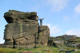
First proper look at Mother Cap
 Apparently the shape of the rock formation closely resembles that of the old mop cap as used in days gone by and that's where the name comes from.
Mother Cap bathed in early autumn sunshine


That's me!!

Me again on Mother Cap

The boys shot from Mother Cap
Another view of Mother Cap

Rob & Ike on Mother Cap

The Blackbrook Explorers on Over Owler Rocks

Ike helping Geoff down from Over Owler Rocks

Stunning views from Over Owler Rocks

More views from Over Owler

Breakfast stop. Introducing new member RAMBO the rabbit.
You will see him in future expeditions but you'll have to search the pics to find him.
Rob taking a rest. You can see Higger Tor & Carl Wark in the background

Toad Mouth Rock is visible from the road. Well it doesn't look like a chicken!!

Ike's photo stance at the milepost on Longshaw Meadow.
We got special permission from the ranger to go into the meadow.

This is Daisy (Well that's what i called her)

Stoop E2 at Longshaw

Another shot of E2

Stoop E1 at the entrance to Longshaw. This has been relocated from its original nearby position.
A modern stone is seen in the background.
 See you next week and don't forget to look out for Rambo.

Monday 5 September 2011

Curbar & Froggat Edges

Hi all
We set off heading north again and passing through Chatsworth Park about 7:00am there were a few hot air balloons getting ready for launch and a couple already in the air.
We once again parked in the lay by just downhill from the Grouse Inn on the A625 and headed up the White Edge. We walked south along the edge looking for stoop marked E3 on our map.

Check the image below with a similar pic at the same spot last week. Last week the sun was shinning and it was a beautiful colourful sky. If you click on the images to make them larger you will see lots of holes in this rock face. Apparently its the result of target practice during the last war.

Rocks on White edge

Stoop E3 on White Edge

We pushed on with the weather turning damp and we had to put on waterproofs and hats to ward off the dreaded midges. They seemed to like Ike the most, well he had the most love bites!!
Just past the stoop we spotted a single female deer just grazing, until we got to close then it was off.
Geoff on a pedestal!!
The white edge trig point lured us off the track and according to the map its 365 M above sea level.
Trig point at 365M
It can be lonely out on the moors, just you and the local cattle.


We stopped at stoop E7 on the map for a welcome cuppa & breakfast.

Stoop E7
 After we had our fill it was off along Curbar edge and more damp weather.

Jim in Rain hat!!

Geoff galloping along the track
From Curbar edge to the Derwent valley below
Bamford edge in the distance.
Rob & Ike waiting at the car.
This walk was just under 5 and a half miles, with good weather the views are just spectacular and well worth a visit.
Next weeks expedition could be led by Ike, so watch this space.